VOC trips are organized by members like yourself, not professional guides. The trips go into wilderness areas where assistance is unavailable and unexpected events can occur. You could be seriously injured or die. You are responsible for your own actions. Please use caution.
Wild Horizon 2025 #3: Bridge Glacier Lake (or Salal Creek – Bridge Glacier Lake) · Fri. Jul. 18th, 2025 - Mon. Jul. 21st, 2025
- Details Page: Where you can see brief trip details (publicly viewable).
- This trip does not have an associated Wiki Page.
- This trip does not have an associated Message Board Thread.
- Signup Page: Where you can signup, bail, edit participation entries, see/email members on the trip, etc.
- Wikitext Page: From where you can cut and paste information formatted for the wiki.
- Printable List Page: Which generates a printable list of participants.
- Edit Page: Where the trip organizer can edit the entry for this trip.
- Mark Going Page: Where the trip organizer can sign members up as "actually going".
- Modify Signups: Where the trip organizer can change signup classes.
Start: Friday, Jul. 18th, 6:00 am
End: Monday, Jul. 21st, 9:00 pm
Pre-trip meeting: Monday, Jul. 14th, 8:00 pm
Pre-trip meeting location: Zoom3264
Description:
ation: 4 Days, 3 Nights
Difficulty: Easy to Difficult
Start Date: Friday, July 18, 2025
End Date: Monday, July 21, 2025
Type: Out-and-Back
Total Distance: 20–35 km (depending on the route)
Min Elevation:1150 m
Max Elevation: 1650 m
Overview
Embark on a breathtaking adventure to Bridge Glacier Lake, a pristine glacial gem shaped by the slow retreat of the Bridge Glacier over the last 30 years. Despite being a mere few kilometers from the nearest car-accessible point, the rugged terrain and lack of marked trails will challenge your navigation skills and spirit of adventure.
If the path to Bridge Glacier Lake proves impassable—due to tricky river crossings or impassable terrain—we'll switch to an alternative route through Salal Creek, offering a more manageable crossing, but a longer journey.
Whichever route we take, you’ll be immersed in the remote valleys and sub-alpine beauty of British Columbia, making this expedition a perfect challenge for those craving the thrill of wilderness exploration.
Itinerary
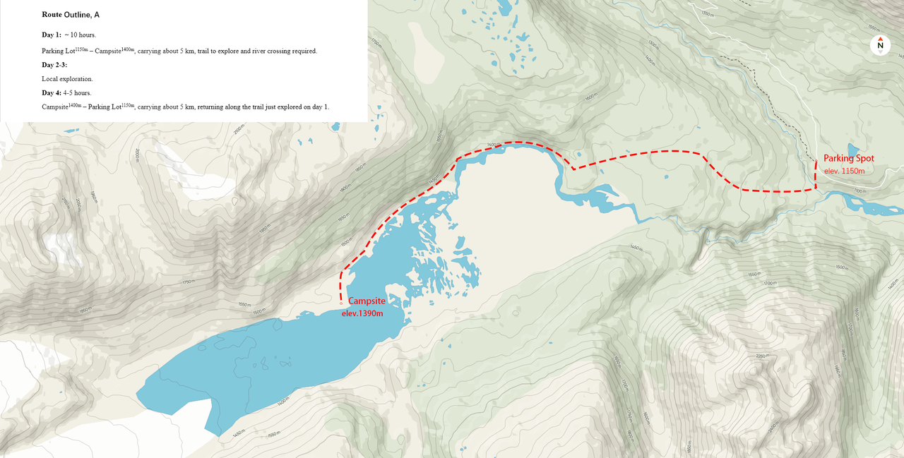
Route A: Bridge Glacier Lake
• Start Point: Parking lot (Lat: 50.861384, Long: -123.393140) (1150 m)
• End Point: Bridge Glacier Lake north shore (1400 m)
• Total Distance: 10 km (round trip)
• Elevation: 1150–1410 m
• Trail Condition: Off-trail, requiring route finding through rugged terrain
Day 1 – Friday, July 18, 2025
• Starting Point: Our adventure begins from the parking area at 1,150 m elevation, heading toward the serene Bridge Glacier Lake
• River Crossing: The first major challenge is the Bridge River — its fast-moving waters can be hazardous. If crossing is not feasible, we will immediately switch to Route B
• Off-Trail Terrain: If the river can be crossed, we’ll face increasingly difficult terrain ahead. With no marked trail and dense, jungle-like undergrowth, route-finding will be slow and demanding — this is a true off-trail experience
• Destination: Our goal is the stunning Bridge Glacier Lake (1400 m), nestled at the glacier’s edge. The journey offers rare views of the retreating glacier and the rugged alpine landscape
• Camp Setup: Once we reach the lake, we’ll set up camp and spend the evening resting, soaking in the peaceful scenery, and preparing for the next day’s exploration
• Estimated Hiking Time: Up to 10 hours. Though the distance is only 5 km, dense vegetation and lack of a trail make the journey exceptionally slow and challenging
Day 2 & Day 3 – Saturday & Sunday, July 19 & 20, 2025
• Exploration: Spend two full days discovering the lake and surrounding wilderness. You may choose to scramble along the shoreline, explore nearby ridges, or simply relax by the water, fully immersed in this alpine sanctuary
Day 4 – Monday, July 21, 2025
• Return Journey: After breaking camp, we’ll make our way back to the parking area. The return trip should be faster with the route now familiar.
• Estimated Hiking Time: 4–5 hours
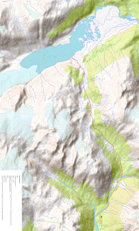
Route B: Salal Creek – Bridge Glacier Lake (If Route A Fails)
• Starting Point: Parking area at 1200 m elevation, located at the end of the Upper Lillooet FSR (note: this area may be undergoing active logging operations)
• Ending Point: Bridge Glacier Lake, south shore (1400 m)
• Total Distance: Approx. 35 km (round trip)
• Elevation Range: 1200–1650 m
• Route Condition: Mixed terrain with partial off-trail sections; river crossing required
Day 1 – Friday, July 18, 2025
• Route Change: If Route A proves impassable, we will shift to Route B. Given the time required for route change and logistics, we will camp near the parking area overnight and prepare for the more demanding trek beginning the next day.
Day 2 – Saturday, July 19, 2025
• Departure: Begin hiking toward Salal Creek, with no established trail through dense forest and rugged sub-alpine terrain
• River Crossing: Salal Creek is typically easier to cross than Bridge River, but still requires caution
• Ascent: Continue along an unmarked route, gradually climbing to a mountain pass at 1650 m elevation
• Destination: Descend slightly from the pass to reach the southern shore of Bridge Glacier Lake (1400 m); approx. 15 km total distance
• Estimated Hiking Time: Up to 15 hours due to off-trail navigation and elevation gain through thick forest
• Camp Setup: Set up camp upon arrival and enjoy the alpine isolation by the lake
Day 3 – Sunday, July 20, 2025
• Exploration Day: Spend the day freely exploring the surroundings of Bridge Glacier Lake. You may choose to scramble along
• Estimated Hiking Time: Flexible, depending on chosen activities
Day 4 – Monday, July 21, 2025
• Return Journey: After packing up camp, we’ll retrace our steps, climbing back to the 1650 m mountain pass, crossing Salal Creek again, and finally descending through the forest back to the parking area
• Estimated Hiking Time: 6–7 hours. The return should be faster thanks to route familiarity
Route Maps
For Route A:
Here’s the full-resolution map for Route A — click to view.
(The preview below may be compressed by the platform.)
For Route B:
Here’s the full-resolution map for Route B — click to view.
(The preview below may be compressed by the platform.)
Transportation & Vehicle Requirements
• Parking Access: 209 km paved road + 103 km rough dirt road to Route A parking area. An additional 103 + 50 km of rough dirt road is required to switch to Route B
• Recommended Vehicles: High-clearance 4x4 vehicles are ideal for the final stretch to the parking area
• Carpooling: Carpooling is encouraged to minimize environmental impact and reduce vehicle requirements
We’d love to bring as many adventurers as possible, but space will be limited by the number of available car seats. Priority will go first to those on the confirmed list, followed by those on the tentative list. Drivers are especially welcome — your contribution is essential, and you’ll always have top priority!
To help everyone share transportation costs fairly and transparently, I’ve created a simple Carpool Cost Calculator. Just enter trip distance, fuel price, and number of people — the spreadsheet will do the rest.
📥 Download Link:
Click here to download Carpool_Cost_Calculator.xlsx
Essential Packing List
• Lightweight tent and sleeping gear
• Layered clothing system (base, mid, and outer layers)
• Waterproof jacket/pants
• Sturdy hiking boots with ankle support
• Navigation tools (map, compass, GPS)
• Food and stove for 3-4 days
• Water filtration system
• Microspikes or crampons (if snow remains on the ridge)
• First aid kit
• Bear spray and proper food storage
• If bringing cellphone or electronic devices, a solar power bank is recommended for recharging
Important Notes
• Personal Responsibility: I am not a certified guide. Each participant is fully responsible for their own safety, decisions, and well-being throughout the journey
• Self-Supported Adventure: Participants are responsible for carrying their own gear, food, and water
• River Crossings: Both routes require river crossings. Participants must be prepared to navigate the waterways safely
• Bear Safety: There may be grizzly bear activity, especially around Salal Creek. All food must be stored in bear-proof containers or hung according to bear safety protocols
• Off-Trail Navigation: The routes involve significant off-trail navigation, so this adventure is recommended for experienced hikers
• Flexible Schedule: Due to the rugged nature of the terrain, expect potential delays. Be prepared for a longer stay if necessary
• Use of AI Tools: To improve clarity and flow, I used AI tools to assist with language editing — but all route planning, content, and ideas are entirely my own
Best Time to Go
The ideal time to attempt this journey is from mid-July to mid-August, avoiding the peak grizzly bear activity from mid-August to October. Early summer snow may still be present on higher elevations, adding to the beauty of the alpine and glacier environment while keeping vegetation manageable.
Join us for a true backcountry adventure, where the rugged beauty of Bridge Glacier Lake and Salal Creek awaits. Whether you navigate the hidden paths of the glacier lake or explore the wilderness surrounding Salal Creek, this journey will be an unforgettable addition to the Wild Horizon 2025 series!
Pre-Trip Meeting
Our pre-trip meeting will be held on Monday, July14 at 8:00 PM (via Zoom).
Please refer to the signup page for the Zoom link.If you’re planning to join the trip but can’t attend the meeting, make sure to email me in advance.
References
Meteoblue: 7-Day Weather
Google Maps: Photo Sphere
WordPress: Bridge Glacier and the Life-Cycle of a Calving Glacier
ResearchGate: Ablation from calving and surface melt at lake-terminating Bridge Glacier, 1984–2013
The Globe and Mail: Troubled waters ahead for shrinking Bridge Glacier in southwestern B.C.
ClubTread: Bridge Glacier in the news...
Bivouac: The Bridge Glacier- Athelney Pass Expedition
3D Satellite Map (top), Bridge Glacial Lake in summer (middle), Icebergs on Bridge Glacial Lake (bottom):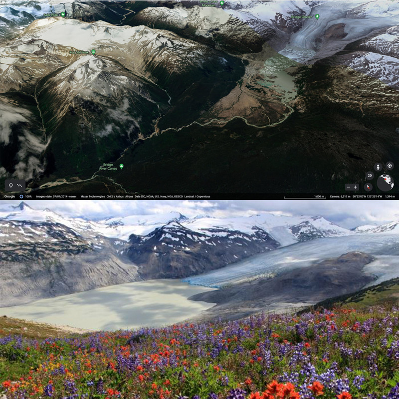

Posted: 2025-04-11 01:42:20
Last modified: 2025-04-16 01:00:31