“’Tis a lesson you should heed,
If at first you don’t succeed,
Try, try again;Then your courage should appear,
For if you will persevere,
You will conquer, never fear
Try, try again…” – T.H. Palmer
The North Shore is a wild place. Most of us find a false sense of security in seeing city lights from atop nearby peaks, accessed from ski resort parking lots and well-established trail networks. Despite this façade of safety, the terrain quickly becomes serious out of bounds. Dense bush makes route-finding difficult, deep snow makes travel arduous, and loose rock is standard. While the North Shore isn’t known for its alpine climbing, it is for precisely these reasons that the local routes have seemed so appealing to me. What else do I seek from alpine climbing than solitude, exploration, and challenge?
There is a trifecta of classic winter alpine climbs on the North Shore in line with my interests: the Crater Couloir on Crown Mountain, the Northeast Buttress of the West Lion, and the North Ramp of Mount Harvey. Descriptions of the (summer) routes in the Wheater guide include inspiring terms such as “adventurous”, “vertical forest”, and “character-building”. Who wouldn’t be intrigued by these descriptions? Inspired by the unique challenges of winter climbing, the winter classic trifecta has been on my mind for several years now. With a superb coastal water ice season coming to a close, I decided I would put my efforts towards these little known alpine-style classics.
These are the stories of my failures and successes in North Shore winter climbing. Three snowy summits have been hard earned by four partners and myself over six trips. My partners and I have wallowed, chopped, kicked, and dragged ourselves through the North Shore’s formidable mountains, gaining a new-found respect for our rugged, beautiful, transit-accessible local peaks.

The Crown Mountain group (left), the Lions (centre), and Mount Harvey (bottom-right).
Part I – the Crater Couloir, Crown Mountain (AI2 / 65° snow / 500m)
January, 2017
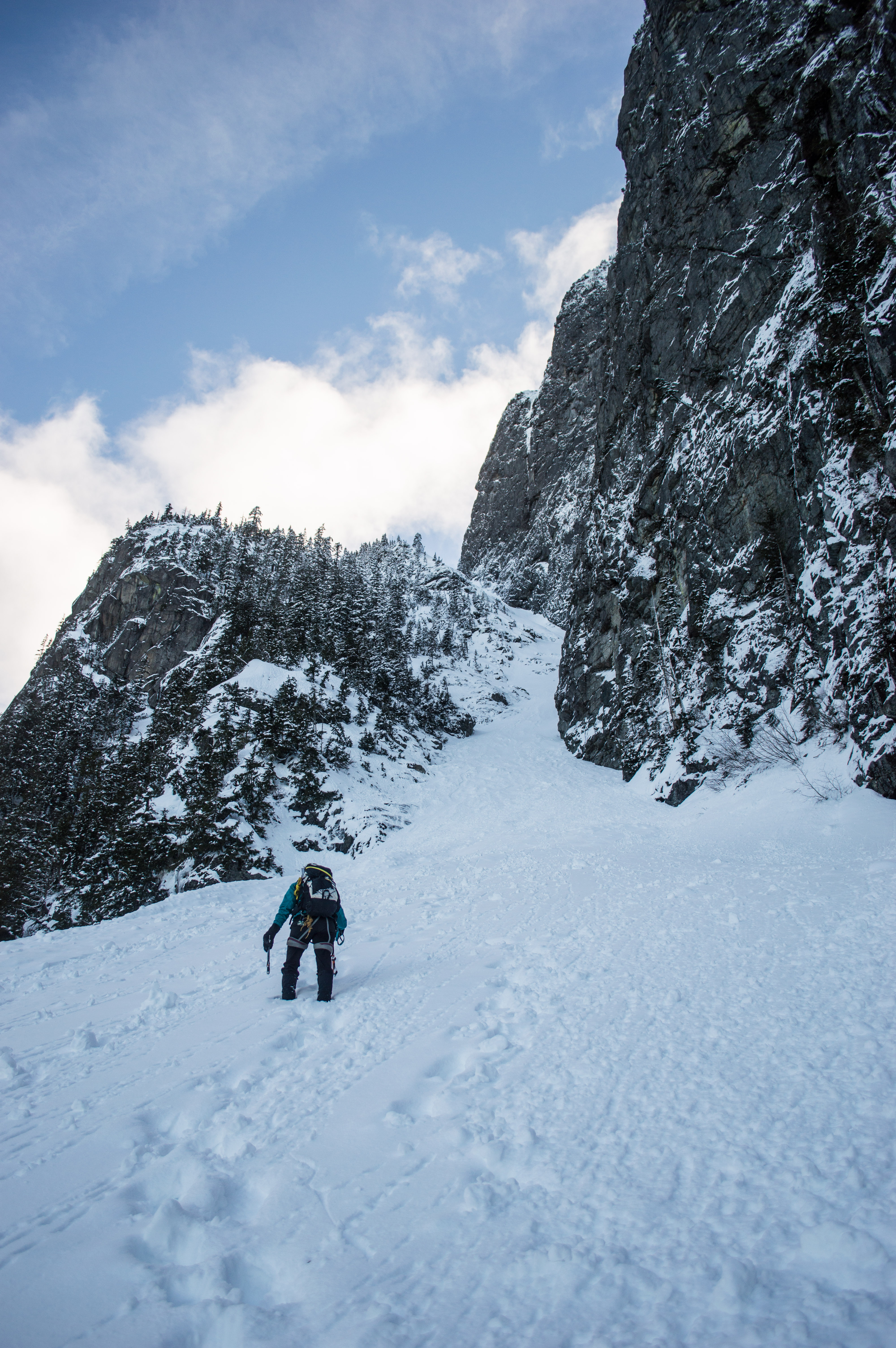
The jagged, snowy summit ridge of Crown Mountain is striking when seen from Vancouver on a bluebird day. The Standard Route up Crown is popular in summer, being easily accessible by the Grouse Mountain tram or the Grouse Grind, and involving mostly hiking with a short final section of airy ridge scrambling. In winter, the classic, snow and ice-choked Crater Couloir climbs 500 meters up the Northeast side of Crown, meeting the exposed ridge below its summit.
Nick Hindley and I attempted the Crater Couloir during a mid-week weather window in January. We jumped at our chance to check the route out, unsure of what condition it would be in, guessing anywhere between three meters of snow and pure water ice. Well, it wouldn’t be winter climbing on the coast if we didn’t take all our heavy, sharp gear for an uncertain slog.
We skirted the fence and cruised up the Grouse Grind, stopping to top our water off at the Grouse lodge, and feeling pretty spoiled. It’s moments like this that make the North Shore feel safe and tame. Before long we slapped our snowshoes and headed up the Snowshoe Grind to the top of Dam Mountain. Down the far side, we followed a well-established snowshoe track along Goat Ridge. We realized we had traveled too far, missing the drop to Crown Pass, when we summited Goat Mountain. Instead of backtracking, we snowshoe-skied down a nearby slope, speedily reaching the Pass. From here it was down further, into the Hanes Valley. All of a sudden the tameness we had felt surrounded by groups of tourist and downhill skiers was replaced by an enveloping sense of wilderness and self-reliance.
Reaching the base of the Crater Couloir six hours after we’d started, we found the remnants of a recent, massive avalanche that had slid down the chute. The already late hour of the day, warmer than expected conditions, and the possibility of (very large) avalanche hang fire convinced us this would not be the day.
The return slog up Crown Pass and Goat Ridge was tough. Too steep for easy snowshoe use, we post-holed the whole way. Putting our snowshoes back on atop Goat Ridge, the firm snowshoe track back to the lodge was a dehydrated blur. We watched in awe as the sun set below the clouds, lighting everything up around us. Returning to the hordes of skiers, we ate burgers and drank beers in the lodge before downloading on the tram.
January, 2017
Dakotah Fozzard and I returned two days later, taking advantage of the good weather while it lasted. We brought our gear on the sky train and two buses, before grinding up from the bus stop to the lodge. From the there it was easy going to the top of the snowshoe grind. I was again struck with how accessible the North Shore Mountains are – it had taken us four and a half hours from doorstep to mountain top.
Having figured out the approach with Nick, and following a now iced-up boot track, we made good time to the base of the climb. The avalanche debris had not gone anywhere, but it was colder and cloudier than before. We figured that any unstable hang fire would have dropped by now, especially with the recent sunny weather.
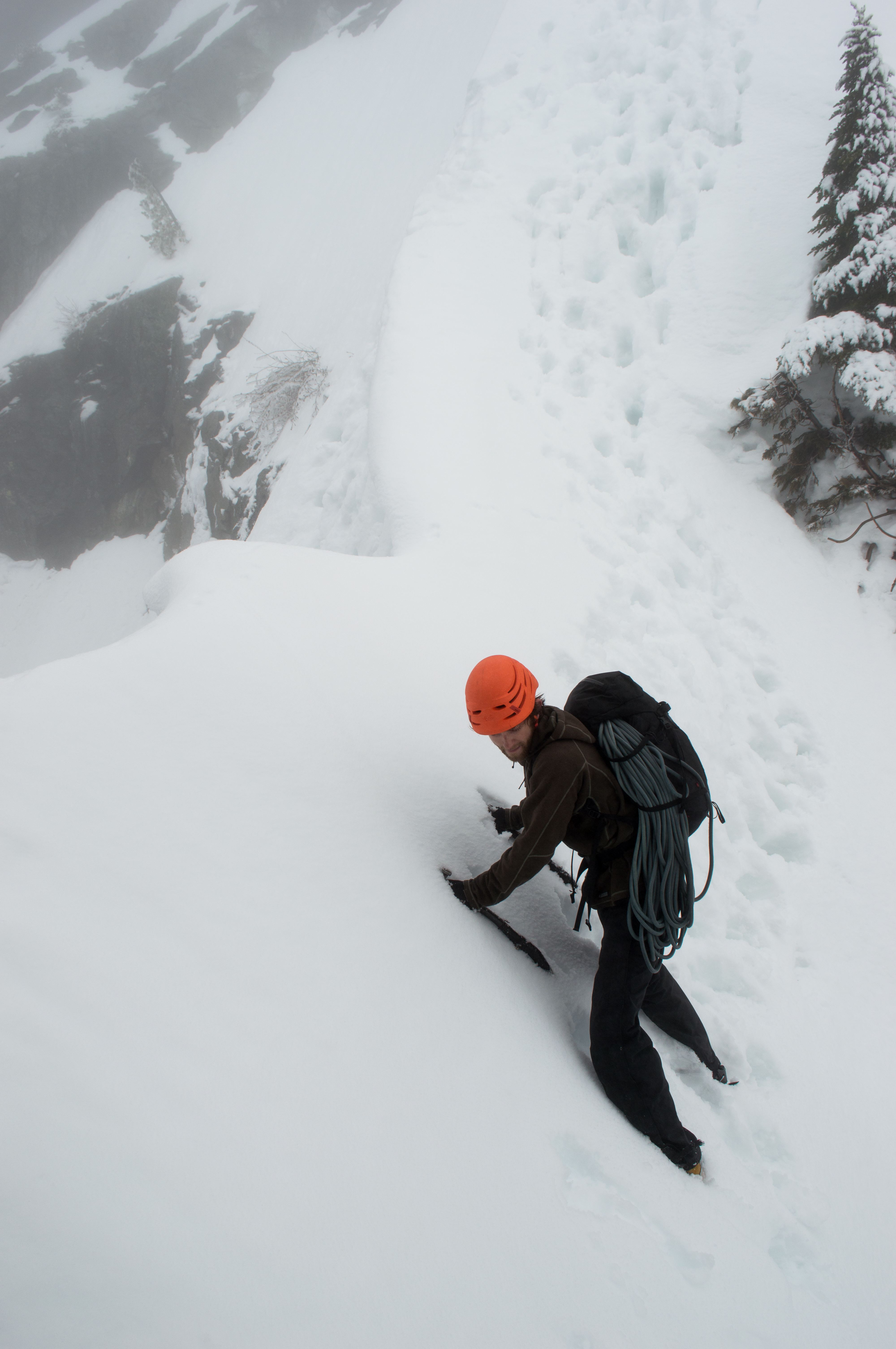
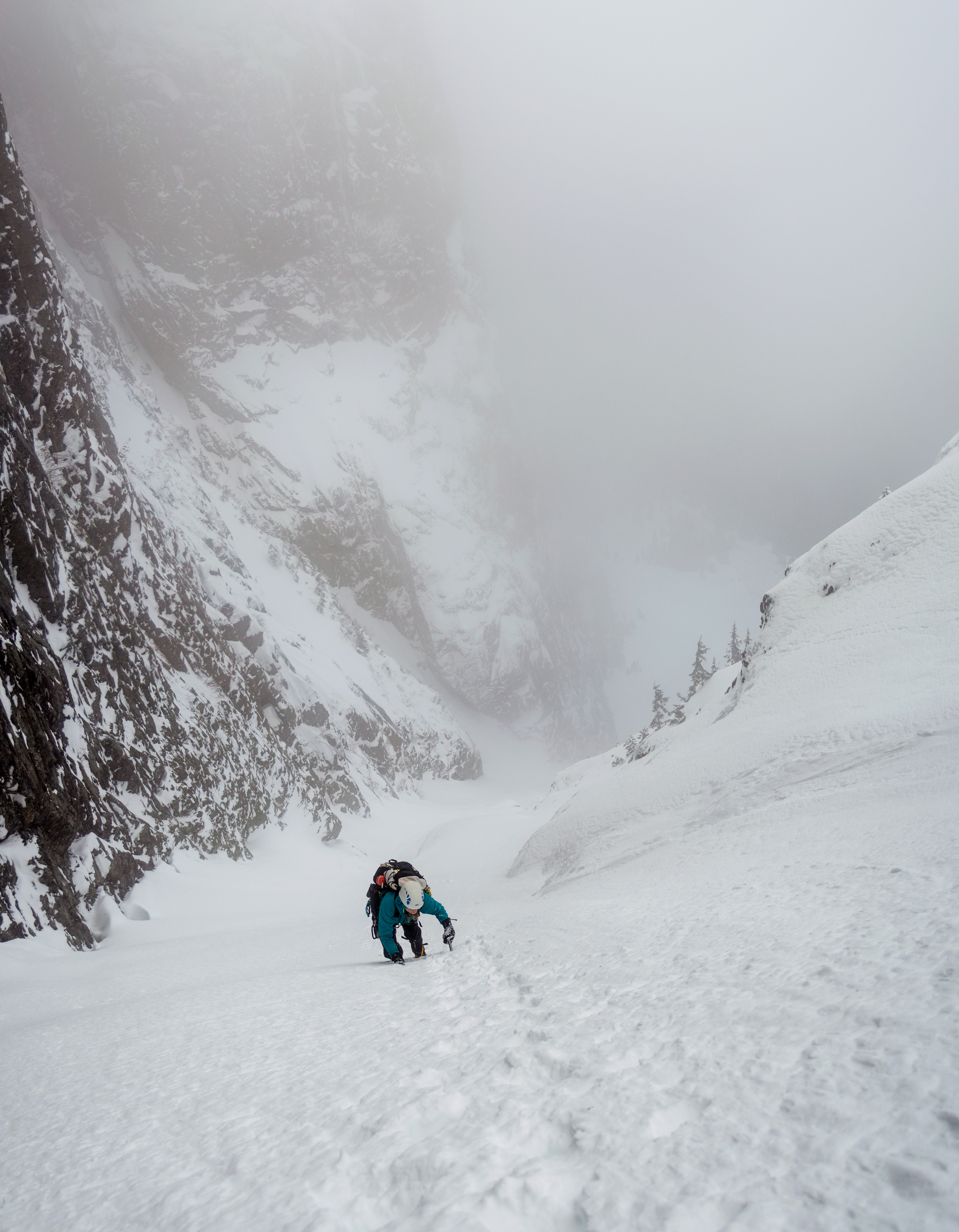
We donned our crampons, pulled out our ice tools, and began threading our way through the avalanche debris. The slide had left a firm snow surface making for quick travel. As the angle steepened, we front-pointed up through the narrowing couloir. About half way up, the couloir narrowed to just a couple meters wide, and an escape showed a direct route to the summit. The couloir looked steep, but the escape crossed a meter-high avalanche crown. A fast-moving sluff passed close to Dakotah as she came to meet me at the junction, and the prospect of crossing a large crown line became immediately less appealing. We decided to rope up and pitch-out the couloir.

Dakotah works her way up the narrow couloir.
A solo climber passed by us with only a single mountaineering axe. Though it seemed silly to have all our gear while he had almost none, there were a few steeper sections of ice that I was glad to be on belay for. After a few pitches, we exited the couloir to a wide snow slope.
It was scary to see the looming icefall-like crown line the big avalanche had left behind. Three meter high serac-like blocks teetered over the route, hidden from below. While I’ve crossed below seracs before, I’ve never done it in such warm conditions, nor without a full grasp of the risks I was taking. We moved fast to gain the summit ridge. Close to the top, Dakotah’s leg punched through a hidden bergschrund. We were stoked to finally reach the ridge!
Stoked to reach the ridge! Photo: Dakotah Fozzard.
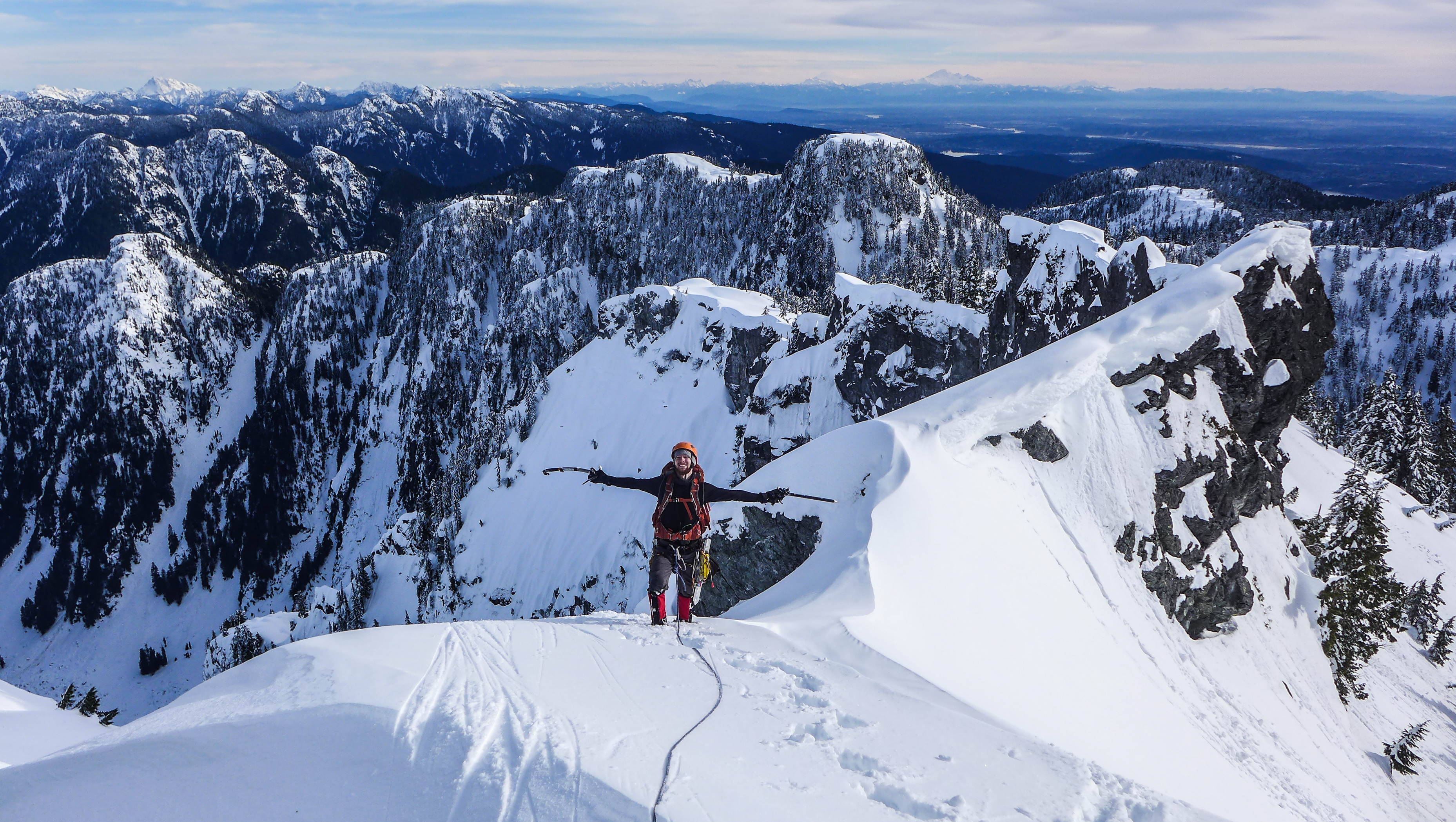
From here, we pitched out three exposed rope lengths to the summit, where I seemed to frustrate the summit raven. It felt good to finally stand atop (or maybe just poke the top of the cornice) one of the most iconic peaks visible from Vancouver. The views were spectacular, of course, and I laughed to see how close the city felt, just a little while after technical climbing and fears of death by icefall. We had taken shy of four hours to climb the couloir.

Dakotah walks the final exposed section of ridge.
Down-climbing the ridge was straight-forward, and we paused where the couloir met the ridge. We were frigid, dehydrated, had eaten little to this point. A rest was much needed.
The descent was easy, following the soloist’s boot track along the summer route. Down to the Pass, up Goat Ridge, along the snowshoe track, and finally to the lodge. We had beer and fries, quickly forgetting numb digits, aching calves, and burning lungs. A tram ride down, two buses and a skytrain ride got us home. It’s pretty cool that remote terrain like this is transit accessible!
Part II – the Northeast Buttress, West Lion (M4 / AI2+ / 65° snow / 450m)
February, 2016
The Lions are perhaps the most iconic local peaks. Two rounded towers appear as heads, while elongated ridgelines seem to be the shoulders and backs of majestic beasts. The higher of these Twin Sisters, the West Lion sees most ascents via the standard Tourist Route, reportedly a straight-forward, exposed summer scramble. On its seldom-touched Northeast side, an aesthetic buttress waves 500 meters from valley to summit – this ridge appears as the right side of the West Lion, when viewed from Vancouver. While obscure, this buttress is climbed most often in summer. In winter, it is a challenging local classic, in one of the most classic settings.
Noah Besen and I scoured the internet for trip reports and beta on winter ascents of the Northeast Buttress, but information was scarce. We gathered that the route was 5.6 in the summer, and contained a fair bit of North Shore shrubbery. Seemed reasonable.
We waited most of winter, 2015/ 2016, for firm snow conditions. Leaving the Lions-Binkert trailhead at sunrise, the approach hike took much longer than we anticipated. Plenty of awkward deadfall maneuvering, post-holing, and sweat got us to treeline. Arriving below the West Lion after three hours, route hidden from view, we speculated at the climb’s condition. It was later than we intended, and the day was pretty warm. We decided there wouldn’t be time to finish the approach underneath the Lion’s North Face, climb the route, and make it down safely.
Instead, we decided to head up an obvious Northwest-facing couloir separating the West Lion’s head from its body. Once in the couloir, the clouds lifted and we noticed the bus-sized cornice overhanging us. We moved faster. Mantling over the (much smaller) cornice at the top of the couloir proved somewhat tricky, but we managed to reach the base of the Tourist Route. Looking up, we discussed trying the scramble, but decided against it. As we hauled on a fixed line to reach the Lion’s back and popular summer viewpoint, the sun came out, immediately releasing chunks of ice and sluffs of snow off the Lion’s head. We felt good about our cautious decisions of the day.
Noah traverses out of the couloir.
I had been to this viewpoint once before in the summer. I remembered crowds of people in various levels of hiking and city clothing. Piles of discarded orange peels, laughter, and cameras abound. At this moment, in periodic whiteouts and blowing snow, I felt far removed from the summer crowds.
February, 2017
Matteo Agnoloni called me twice before I woke up in a hungover flurry. I was an hour late to our meeting spot. We began hiking up the Lions-Binkert trail, and I was still seeing stars. Though it was almost exactly a year from my previous attempt, we found snowline and approach conditions to be similar. That is to say, we spent much more time than anticipated post-holing and perfecting our bush parkour technique. How did I not remember the approach being like this? We should have left earlier – I had to be home for my birthday party at 19:00.
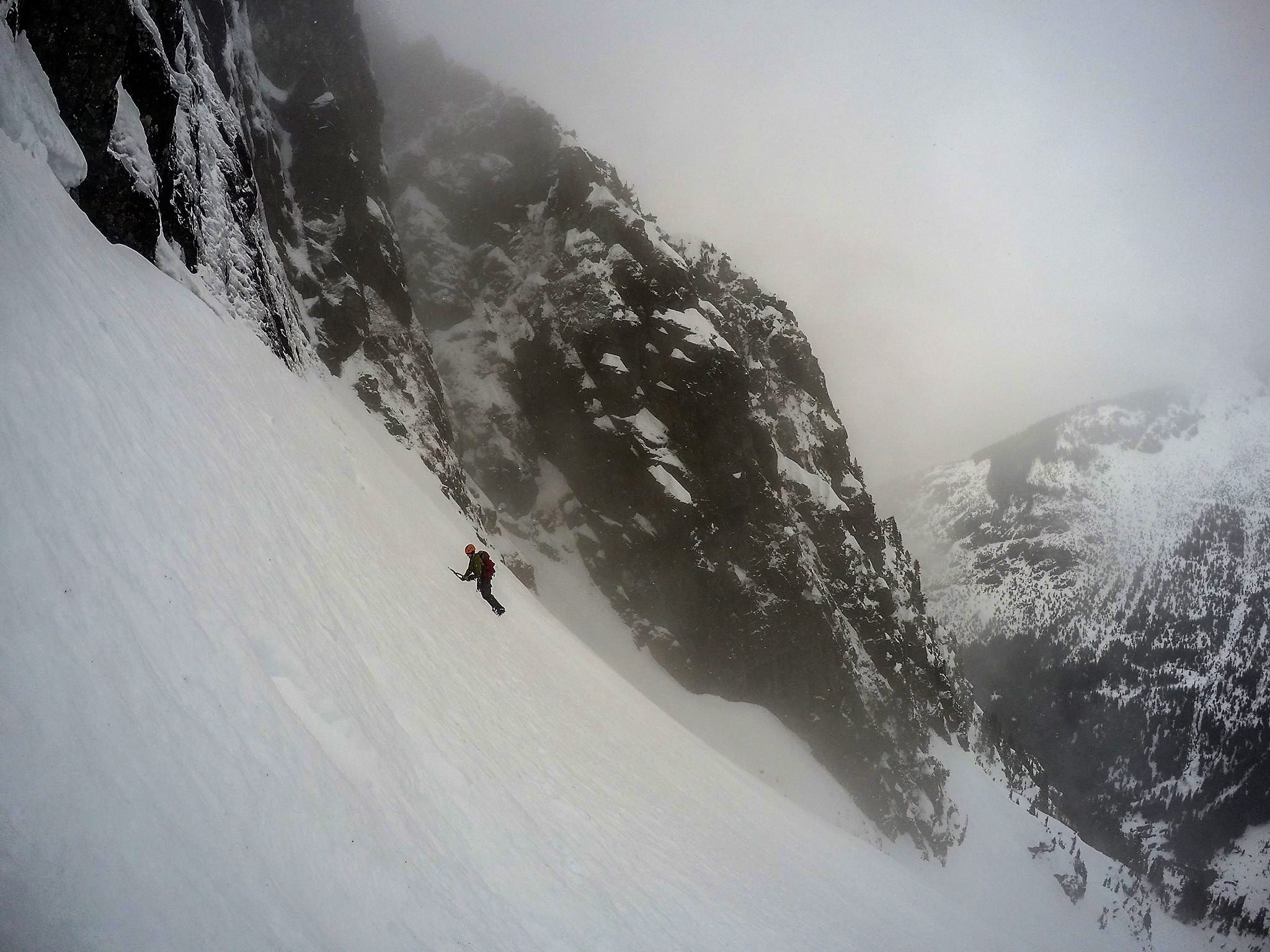
We took a quick break at treeline before dropping our snowshoes and heading through the Gunsight Notch. At the top of this mini-couloir we put on our crampons and took out our tools. The snow took our front-points perfectly, and we descended quickly to beneath the imposing North Face. Looking up through blowing snow at the grey rock, white ice, and black couloirs, I once again felt far removed from the tameness of the tourists’ lookout in summer.
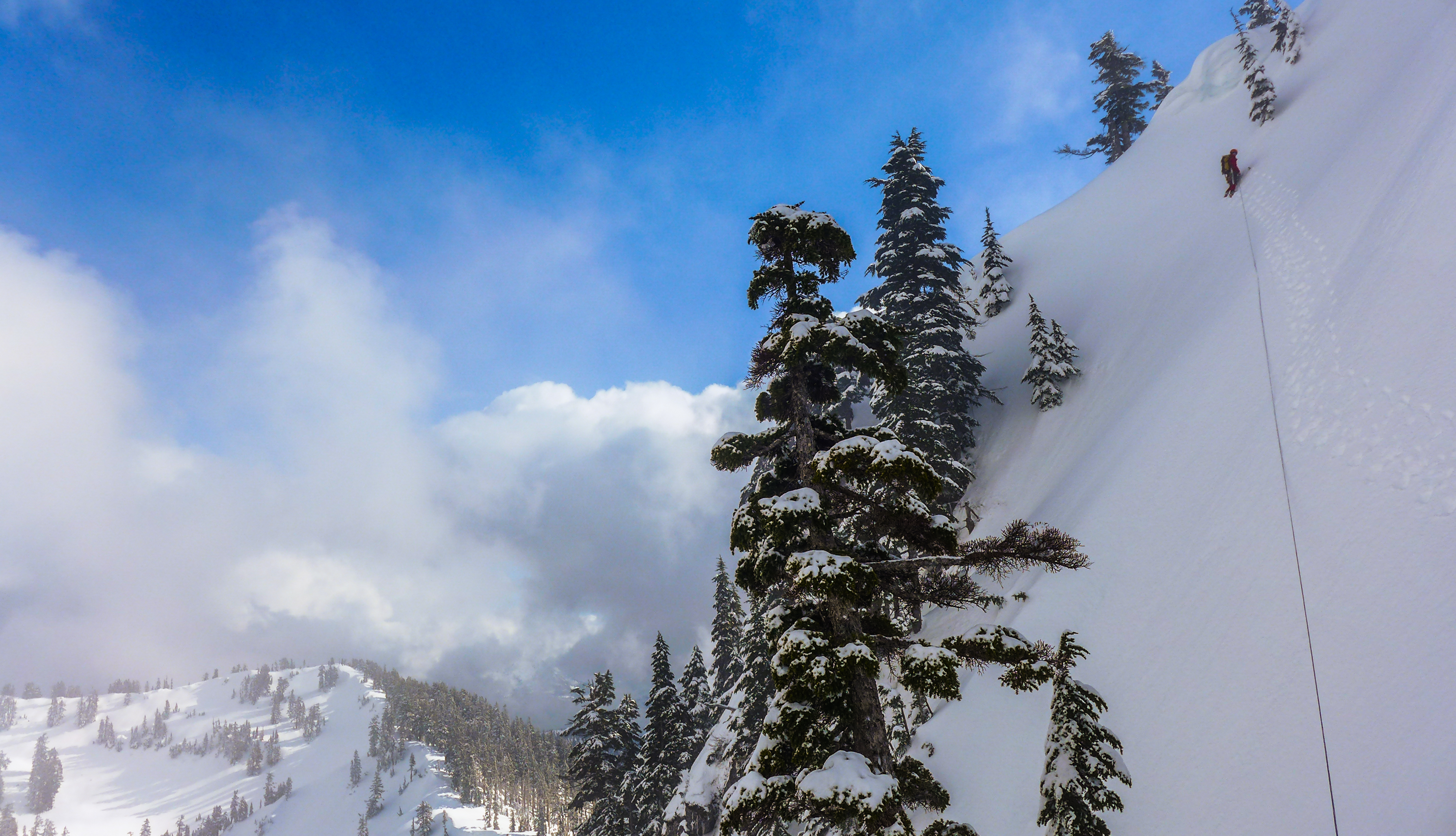
We decided to follow a 45 degree snow ramp below the North Face, meeting the Northeast Buttress about a third of the way up, and cutting out a few technical pitches. This would save us a lot of time – important, considering our later start and arduous approach. We negotiated some small bergschrunds and began traversing below the Face. The firm snow made for secure tool placements, but our calves burned over hundreds of meters of front-point traversing. Periodically we were forced to stop, plant our tools firmly, and brace ourselves against small sluff avalanches racing down the face.
Traversing below the North Face. Photo: Matteo Agnoloni
We reached the Buttress five hours from the car. The terrain appeared generally mellow just above us to a group of trees would make a good initial belay. We started upwards, first through firm snow, then thick alpine ice. About ten meters below the trees, the ice steepened and thinned to almost nothing. We discussed our options, as roping up in our precarious situation would be challenging (and Matteo didn’t have his harness on). A tree to our left was out of reach down the sheer East Face. A tree to our right was barred by more steep, thin, awkward ice that I wasn’t comfortable crossing unroped. With no better choice, Matteo took an end of the rope and charged upwards to the trees. After putting on his harness and making an anchor, he belayed me up. I was impressed with his short solo (considering his first ice lead was a few weeks prior), and glad to be on belay myself. Matteo’s eyes asked the standard question: “why do we enjoy this?”
Following Matteo’s solo. Photo: Matteo Agnoloni
I racked up and climbed our first true pitch. Steep snow was made tricky when a thick rain crust sheared off under my feet. Some digging was required, as were a few delicate mixed moves. The final few meters required yanking on handfuls of frozen shrubbery, feet and ice tools dangling off the East Face. Ah, North Shore alpinism! I belayed from a horn, supported by these same shrubs, a rain crust, and little else.
Matteo took the second pitch, up 70+ degree alpine ice through the Vertical Jungle, an icy tunnel of bushes. As I sat and looked down the sheer face below me, I listened to the whooshes and crashes as chunks of ice barreled through the trees and spun off the East Face while Matteo excavated his way upwards. I was glad to follow up and move my toes again.
From here I led up a short ice chimney with a couple delicate exit moves, then along a moderate snow slope, to a pile of balanced rocks. A meter-wide gap separated this tower from the continuing ridge. Carefully balancing my crampons on rock I struggled to find purchase for my tools. The view down to the valley bottom through the gap was dizzying. Mantling carefully across, I flopped into the snow on the other side. I felt this to be the route’s crux.
Matteo led the final snow and ice sloped to the summit. It was a good feeling to crest the ridge and see him belaying from a snow seat, right at the mountain’s apex. We took a brief moment to gather ourselves for the descent. It had taken us ten hours from trailhead to summit. While protection had been easy to come by the entire route, the rain crust and exposed climbing had made for hard work.
The sun settled below the clouds, lighting up the East Lion in spectacular fashion. The snow and mist around us became a golden mantel before the sun hid itself once again. The lights of the Cypress Ski resort shone through the clouds. Friends, home, and birthday celebrations felt a long ways away.

Summit stoke! Photo: Matteo Agnoloni
We made three traversing single rope rappels down the Tourist Route, pulling the last at a spot just below the notch between the West Lion’s head and back. We solo’d up one last icy slope to reach the fixed rope which seemed laughably unhelpful compared to our ice tools. We reached the viewpoint in a full-on nighttime whiteout. It took a number of cliffed-out wrong turns to find our snowshoes again, each one seeming to put me further away from seeing my friends. The descent was brutal and full of post-holing.
This route was no doubt some of the most fun I’ve had on a winter climb to date. I had so much fun, I arrived five hours late to my birthday party, finding everyone gone, lights out, and girlfriend asleep.
Part III – the North Ramp, Mount Harvey (65° snow / 500 meters)
January, 2017
Mount Harvey is one of the highest peaks on the North Shore, and is notable from Brunswick, the Lions, and the Howe Sound Crest Trail. In the summer, it is a popular summit accessed via hiking trails from Lion’s Bay and the Howe Sound Crest Trail. In winter, its North Ramp is one of the most frequently climbed local routes.
Dakotah and I saw a desperate weather window, and decided to give the North Ramp a shot. Snow was forecast to start somewhere between 10:00 and 12:00. If we woke up early, got past the steeps onto mellower ground fast, the avalanche conditions should be alright for the descent, even if a forecast 5+ centimeters fell all at once.
We got to the trailhead a couple hours before sunrise. As we stepped out of the truck, the snow began to fall. We were on our way quickly, but the snow fell quicker. By the time we were at the base of the climb an hour and a half later, 6 centimeters of snow had already collected atop a firm crust.
We debated our plan over a snack. As the avalanche forecast stood, we were headed into the terrain explicitly warned about. With heavier than expected snowfall that showed no sign of letting up, bailing seemed smart. We poked our heads out of the forest to check out the bottom of the route through the clouds and watched as constant sluffs poured off Harvey’s North Face.
February, 2017
Our second attempt started at an equally dark hour. Once again reaching the base of the couloir, conditions seemed good. We racked up with numb fingers, and began upwards. The crunch of crampons in snow and the jingle of climbing gear broke the early morning stillness. Now away from the well-traveled logging road, we felt removed from the perceived docility of these mountains once again.
Dakotah approaches Harvey’s North Ramp.
Just a little ways into the couloir, it became apparent that we would be alternating between kicking steps in firm snow and wallowing though steep, waist deep powder. This made for tough going at first, but became easier as we got into a groove of kicking steps and plunging ice tools. Numb fingers warmed, and warm toes numbed.
The bottom third of the couloir was pretty mellow. About this point, the couloir turned and steepened to around 65 degrees. The steps were easy to kick, and we only swung our ice tools in a few spots. The angle eased off for the top third, and we stopped at a shoulder to have a snack and catch our breath.
Climbing the steeps.
We took out the rope here, anticipating a steep, exposed traverse far above the meadows below. According to trip reports, this section could be spooky, and we wanted to be prepared. In reality, we found the angle to be no more than what we’d been on in the couloir, and the exposure seemed less than looking down the fall line in the ramp. We brought pickets to place as protection, but there were enough trees we felt confident that, if something bad happened, we would simply end up tangled up around them.
The infamous traverse. Photo: Dakotah Fozzard.
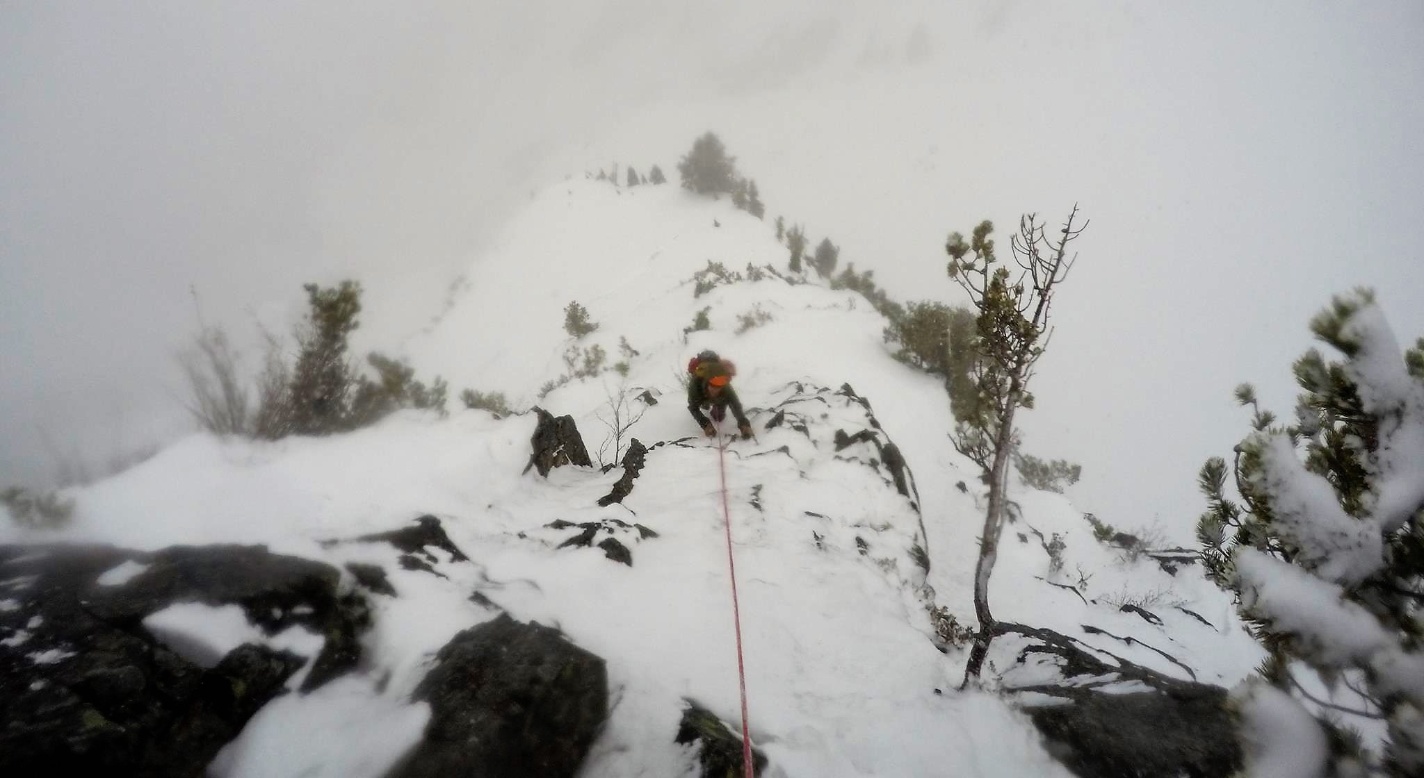
Past the traverse, Dakotah took lead and brought us to the top via the Northeast Ridge, and a couple more short, steep sections with ample trees for protection. The summit greeted us with glorious sun and sporadic views of the surrounding peaks, three and a half hours from the couloir’s entrance. We saw the fabled Brocken Spectre: our shadows in the mist, surrounded by rainbows and anti-crepuscular rays. We lazed in the sun for an hour, discussing a million more winter climbs on our lists. So rarely have we had the freedom to spend so long on the summit of a winter climb!
The descent via the Normal Route was easy in the boot track of some people who had apparently been on the summit shortly before us. The remote feeling from the bottom of the couloir faded quickly. Slalom butt slides through the trees were efficient and fun!
Compared to my other North Shore winter classic climbs, Harvey seemed the most straight-forward, though it shared the same adventurous feel and spectacular situations.
Epilogue, Gear Notes, and Beta Photos
I have gained an immense appreciation of the North Shore Mountains through these trips. Time and time again they have humbled me with their beauty and challenge. Each trip took longer than expected – usually by a large margin – and each left me feeling more in tune with these underappreciated peaks.
Every summit made was one on which I had never stood before, and there are countless more peaks to touch and routes to climb in these rugged mountains. While these stories tell of my introduction to North Shore alpinism, I expect there to be many more stories soon. Summer and winter, these mountains have a lot to offer. Get after it! But play it safe – the Mountains always have the final say.
Gear notes: In general, we didn’t find snowshoes or skis useful enough to justify for the approaches of these climbs. This is probably true for most good climbing conditions. Our racks generally consisted of nuts, tricams, a couple short ice screws, a few big hexes, six-ish alpine quickdraws, and a few double-length runners. Though we used a couple hand-sized cams on the West Lion, I wish we had smaller cams instead. We used a couple pickets on Crown, and only trees as protection on Harvey. A single 70 meter rope was good for pitches, and excessive for simul-climbing. Two ice tools was necessary for the West Lion, and a tool/ axe combo was sufficient for Crown and Harvey. We brought avalanche gear for each climb. No doubt there are those who would do these routes with little more than crampons and a single axe – my partners and I are certainly not those people.
Note that each of these climbs is transit accessible!
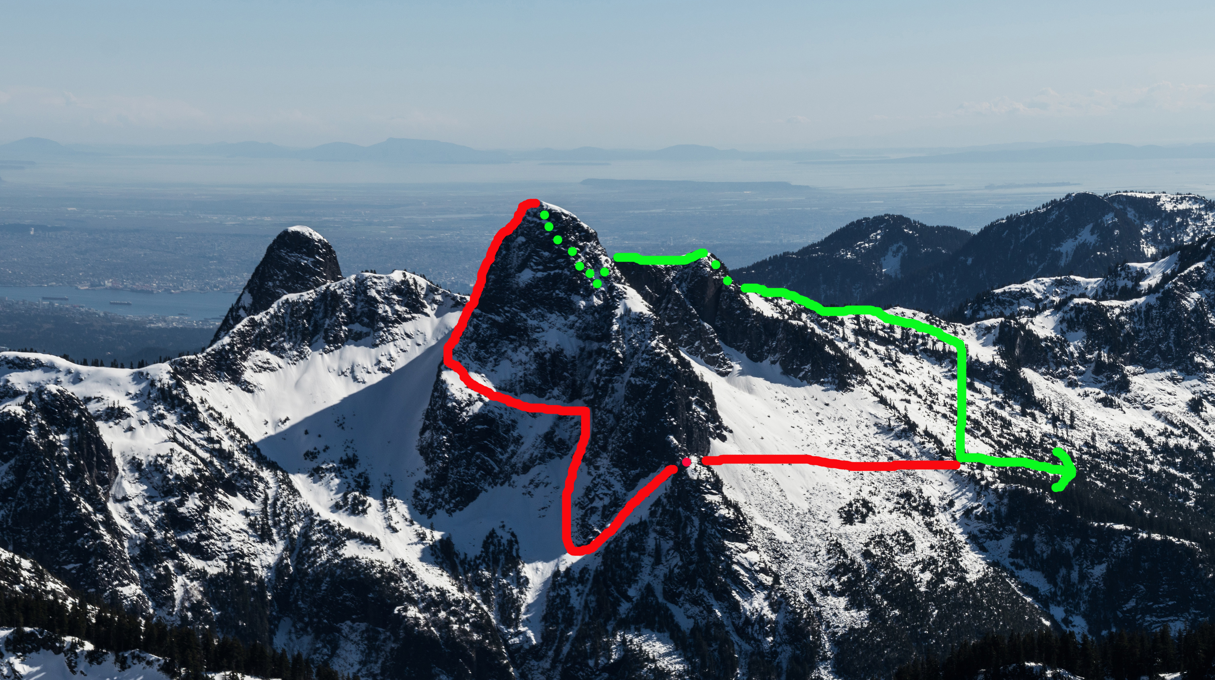
Beta Photos: Red indicates ascent, green indicates descent; dotted line indicates hidden from view.
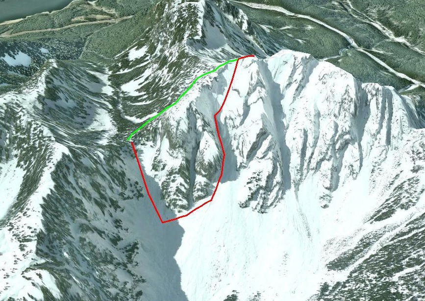
Crown Mountain. Ascent from Crown Pass via the Crater Couloir (red), and descent via the Standard Route (green). Google Earth image.
The West Lion. Ascent via the Northeast Buttress with North Face bypass (red) and descent via rappels down the Tourist Route and Lions-Binkert trail (green). Photo taken from Mt. Brunswick.
Note: see Heinrik Hinkkala’s TR for more detailed topos and route information on the West Lion’s Northeast Buttress HERE

Mount Harvey. Ascent via the North Ramp (red), descent via the Standard Route (green). Photo taken from Mt. Brunswick.
A M A Z I N G
Very impressive and beautifully documented!